
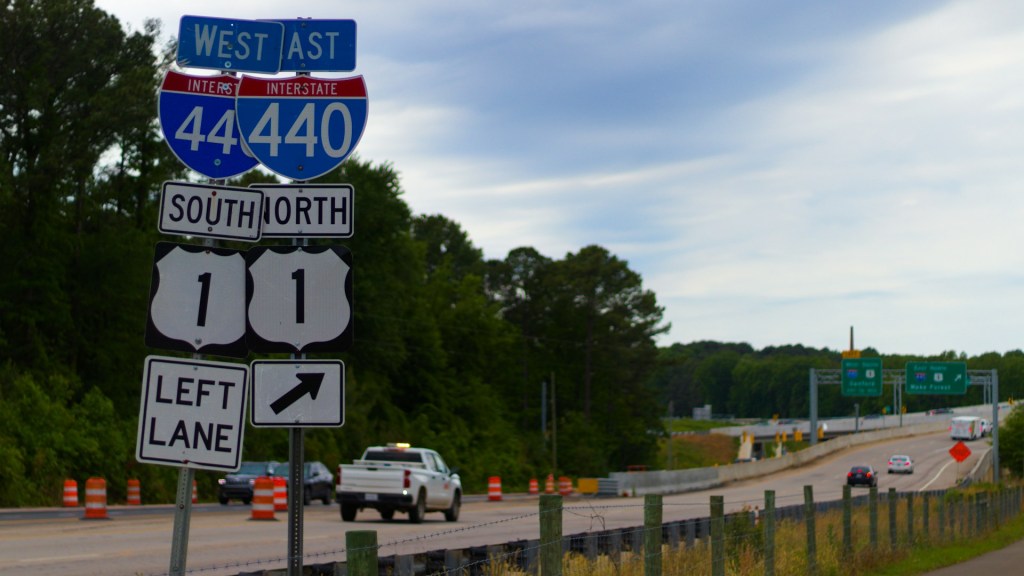
How do interstate highway numbers work? Interstate highway numbers follow a national grid. Odd numbers mark routes that run mainly north-south and rise from west to east, while even numbers mark routes that run mainly east-west and rise from south to north. Two-digit numbers identify the primary routes, and three-digit numbers identify the auxiliary routes that serve metropolitan areas. Once you know that pattern, the interstate highway numbering system works like a map legend printed on every shield. This article explains the odd and even rule, the meaning of the extra digit on three-digit routes, how mile markers and exit numbers are assigned, how interstate route numbers differ from U.S. Highway numbers, how Hawaii, Alaska and Puerto Rico fit in, and how the 1956 law and the 1957 plan produced the system.
What do odd and even interstate route numbers mean?
Odd numbers belong to north-south routes and even numbers belong to east-west routes, according to the Federal Highway Administration and the Texas Department of Transportation. The lowest north-south numbers begin in the west and the lowest east-west numbers begin in the south, as both agencies describe it, with I-5 along the Pacific coast and I-10 along the southern border of the country.
The pattern extends to the far end of the grid. Routes ending in 5 are the major north-south corridors and routes ending in 0 are the major east-west corridors, according to the Interstate Guide and California Highways. The Drive adds that I-5 is the westernmost of the north-south routes and I-95 the easternmost, while I-10 crosses the southern states and I-90 the northern ones. The Texas Department of Transportation notes that the original plan reserved endings of 5 and 0 for these long routes, which is why the odd and even rule was introduced for the numbers in between.
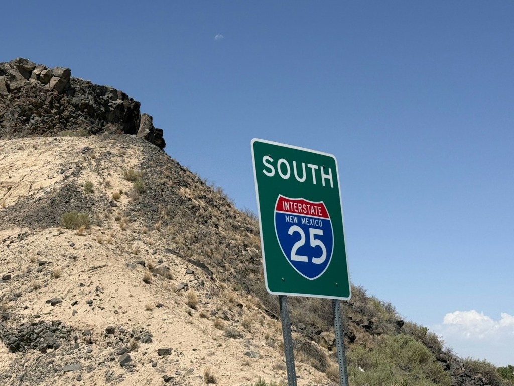
In practice, a driver can use the number as a compass. A route such as I-25, which appears in the photograph below, is an odd number and therefore runs mainly north and south. The Texas Department of Transportation describes the grid as one in which a new number generally falls in sequence between two existing routes.
What do three-digit interstate route numbers mean?
Three-digit numbers mark routes that connect to, bypass or enter a city from a primary interstate. The last two digits identify the parent route, and the first digit tells the driver what kind of auxiliary route it is, according to The Drive and California Highways.
An even first digit marks a bypass, beltway or connector that loops around a city and returns to its parent route. An odd first digit marks a spur that heads into a metropolitan area and does not reconnect, as The Drive, California Highways and the Federal Highway Administration all explain. The Texas Department of Transportation applies the same rule to loops, noting that the first digit is even and the last two digits match the interstate that carries the major traffic stream.
Exceptions exist. The Interstate Guide and California Highways both say that some three-digit routes do not follow the rule, and that I-99 in Pennsylvania does not fit the grid at all. Some major routes also split in two. According to the Federal Highway Administration, the Interstate Guide and California Highways, the I-35 split in the Dallas and Fort Worth area is one of the few places where a directional letter, in this case E and W, survives on a route number.
How do mile markers and exit numbers work on interstates?
Mile markers count from the western or southern end of a route and rise as you travel north or east, according to the Arizona Department of Transportation and the Indiana Department of Transportation. On a north-south interstate the count therefore starts at the southern state line, and on an east-west interstate it starts at the western state line.
Exit numbers usually copy the mile marker. The Arizona Department of Transportation gives the example of an exit near milepost 8.7, which is numbered Exit 8, and the Indiana Department of Transportation says Exit 103 on I-65 sits at or very close to Mile Marker 103. This is useful because subtracting two exit numbers tells you roughly how many miles (and kilometers, at about 1.6 kilometers per mile) lie between them. Some states instead number exits in order, 1, 2, 3 and so on, regardless of distance, as both the Arizona Department of Transportation and the Federal Highway Administration report.
The numbering of exits is a separate matter from the shape of the interchange itself. For the engineering behind one common design, see our article on why highway exit ramps are cloverleaf shaped.

How are interstate numbers different from U.S. Highway numbers?
The two systems use the same odd and even logic but in opposite directions. U.S. Highway numbers begin low in the east and north, with the lowest odd numbers in the east and the lowest even numbers in the north, according to California Highways on U.S. numbering. The Federal Highway Administration FAQ gives the matching examples: U.S. 1 is on the East Coast and I-5 is on the West Coast, while U.S. 10 is in the north and I-10 is in the south. The U.S. system itself dates from the 1920s, according to California Highways on U.S. numbering and The Drive, and the FHWA history calendar says the interstate plan was a “mirror image of the numbering plan for U.S. routes.”
Interstate planners also avoided reusing a number that a U.S. Highway already carried in the same state. The Federal Highway Administration FAQ, RV Travel and the Interstate Guide all describe this non-duplication rule. It explains why there is no I-50 or I-60: U.S. 50 and U.S. 60 were long-established routes, and the Federal Highway Administration FAQ and RV Travel both say the numbers were skipped rather than risk confusion.
How do Hawaii, Alaska and Puerto Rico fit in?
Each uses its own prefix. Hawaii has H-1, H-2 and H-3 on Oahu, signed as interstates, according to the Federal Highway Administration “Ask the Rambler” column and California Highways.
Alaska has four routes numbered A-1 through A-4, and Puerto Rico has three numbered PRI-1 through PRI-3, according to the Federal Highway Administration “Ask the Rambler” column and California Highways.
How did the 1956 law and the 1957 plan create the numbers?
President Dwight Eisenhower signed the Federal-Aid Highway Act on June 29, 1956, according to the Federal Highway Administration FAQ and California Highways. The Federal Highway Administration and California Highways both tie the law to the network’s official name, the National System of Interstate and Defense Highways.
The numbers came a year later. The Federal Highway Administration FAQ says the state highway officials’ association known as AASHO applied the numbers and the Bureau of Public Roads adopted them in September 1957. The FHWA history calendar confirms the same timing: the association’s route numbering committee adopted a numbering policy in August 1957, and the federal administrator approved the plan on September 10. The Federal Highway Administration says officials of AASHTO developed the numbering procedure, and California Highways says AASHTO must approve numbers that states propose. For another look at roads and the engineering behind them, read how traffic lights detect motorcycles.
What was left out, and why?
Several details were dropped because only one source supported them or the sources conflicted. These include the exact dates on which Hawaii’s routes were designated, the claim that Alaska’s routes are signed with state route shields, the statement that the numbering prefix restarts across state lines, the example of I-24 and U.S. 24 sharing a number in Illinois, the name of the person who applied the numbers in 1957, the federal rule on exit numbering methods, the reasons milepost exits are preferred, the 1956 law’s funding provisions, and the full expansion of the AASHO name. Sources also describe the 1956 law as both creating and renaming the system, so the article uses the wording the sources agree on.
Frequently asked questions
Why do interstate numbers go up toward the north and east?
Interstate numbers rise from west to east for odd routes and from south to north for even routes, according to the Federal Highway Administration and the Texas Department of Transportation. The result is a grid with I-5 on the Pacific coast, I-95 on the Atlantic side, I-10 in the south and I-90 in the north.
Is there an I-50 or an I-60?
No. The Federal Highway Administration FAQ and RV Travel both say planners skipped those numbers because U.S. 50 and U.S. 60 already served many of the same states.
What is the difference between I-70 and I-270?
I-70 is a primary east-west route, while I-270 is a three-digit auxiliary route. An even first digit means a bypass or beltway tied to its parent, according to The Drive and California Highways.
Do exit numbers always match mile markers?
Many states match them, but not all do. The Arizona Department of Transportation and the Indiana Department of Transportation describe milepost-based exits, while the Arizona Department of Transportation and the Federal Highway Administration also report that some states number exits consecutively.
Why are Hawaii’s highways called interstates?
Both the Federal Highway Administration “Ask the Rambler” column and California Highways list H-1, H-2 and H-3 on Oahu as signed interstates.
Thanks for reading. If you enjoy clear explanations of how the world works, subscribe on YouTube at https://www.youtube.com/@mrglobalrankss.
Related reading: Why U.S. highway exit ramps are cloverleaf shaped and How traffic lights detect motorcycles.
Sources
- Federal Highway Administration: Interstate System
- Federal Highway Administration: Interstate Frequently Asked Questions
- Federal Highway Administration: Highway History, August 14, 1957
- Texas Department of Transportation: Interstate Highway Numbering
- Interstate Guide: Interstate Numbering Guide
- California Highways: Interstate Highway Numbering
- California Highways: U.S. Highway Numbering
- The Drive: The Surprising Logic Behind Interstate Highway Numbers
- Arizona Department of Transportation: Why Exit 178? A Guide to Interstate Exit Numbering
- Indiana Department of Transportation: Interstate Routes, Mile Markers and Exit Numbering
- RV Travel: Why Isn’t There an I-50 or I-60?
- Federal Highway Administration: Ask the Rambler, Interstates in Hawaii


Leave a Reply